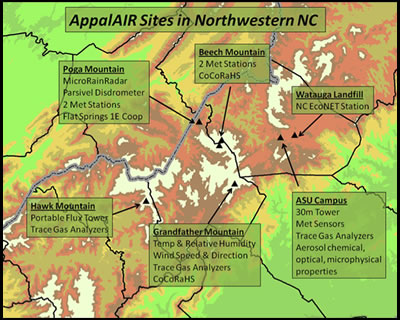
AppalAIR also manages additional meteorological research stations at Hawk Mountain, Poga Mountain, Beech Mountain (in cooperation with Ski Beech), Grandfather Mountain (in cooperation with Grandfather Mountain and the State Climate Office), and the Watauga County landfill (in cooperation with the State Climate Office).
- Flat Springs (3350 ft – northern Avery County and location of Perry Family Farm): Parsivel disdrometer and present weather sensor, Pluvio weighing precipitation gauge, standard meteorological sensors (temperature and relative humidity, pressure, soil temperature). This location is also an official NWS cooperative observer station, Flat Springs 1E. Real-time data.
- Poga Mountain (3740 ft – northern Avery County and peak elevation of Perry Family Farm): Vaisala WXT510 multisensor (includes wind speed, wind direction, temperature, relative humidity, pressure, and precipitation) on a 10 m tower. Real-time data.
- Beech Mountain Top (5500 ft): Standard meteorological sensors (wind speed and direction, temperature, and relative humidity). Real-time data.
- Beech Mountain Base (4600 ft): Temperature and relative humidity. Real-time data.
- Grandfather Mountain (5300 ft): Wind speed and direction, temperature, and relative humidity. Real-time data.
- Watauga County Landfill (3254 ft): Full met station operated by the State Climate Office and supported by Appalachian. Part of the SCO EcoNET. Real-time data.